Trending
The projected crest for the Ohio River in Wheeling fell slightly Friday evening.
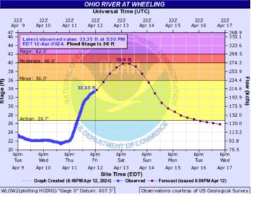
The river now is predicted to crest at 39.8 feet, down from the 39.9 feet predicted earlier in the day. At 5:30 p.m. Friday, the Ohio River measured 33.35 feet in Wheeling.
A flood warning is in effect until early Monday morning, according to the National Weather Service.
3:30 p.m. update
City of Moundsville leaders are warning residents that a flooding situation similar to last week is expected to happen again Friday and Saturday.
Areas that received water last week are anticipated to be flooded again. According to the city's social media, the Ohio River is expected to crest at 41.6 feet on Saturday, making flooding “imminent.”
The following will likely be affected, based on elevation:
Water Street, Thompson Avenue, Jackson Avenue – at 13th and 14th Streets;
13th Street Boat Ramp;
Riverfront Park;
Varlas Campground;
Prima Marina;
Blazer’s;
Bledsoe Campground;
Cho Lee Campground;
10th Street Boat Ramp;
Kudlak Campground;
Monarch Stadium;
City RV Park; and
Co-Op Propane Tanks.
"Please be aware of rising water, and take all necessary steps to protect life and property. The city will again be placing barricades as needed. Please do not drive around these barricades – they are for your safety," according to the city's social media.
2 p.m. update
Ohio County Emergency Management Agency Director Lou Vargo says those needing help with flooding issues need to "call a human," and not post their issues on social media.
Social media posts often don't get read immediately during an emergency, he explained.
"It might be hours. Call and talk to a human being," Vargo said.
Those experiencing flooding and other weather-releated emergency should call (304) 234-3711 - which rings in to the County 911 Dispatch Center.
12:45 p.m. update
Wheeling Island Hotel-Casino-Racetrack will close today at 5 p.m. due to the threat of flooding from the Ohio River and will remain closed until further notice, the hotel announced this afternoon.
All promotions for today are cancelled. Look for updates on the Wheeling Island Hotel-Casino-Racetrack website, social media and email.
11:15 a.m. update
The National Weather Service now predicts the Ohio River Will crest at 39.9 feet sometime Saturday evening. That puts the crest just underneath moderate flood stage.
At that point, the southern tip of Wheeling Island, including Wheeling Island Stadium and the Wheeling Island Hotel-Casino-Racetrack, will all be flooded. At 40 feet, backwater flooding begins to affect Main Street near the water treatment plant in Wheeling.
Last week, the Ohio River crested at 41.49 feet. At 39.9 feet, it would be the 29th highest crest ever recorded in Wheeling.
10 a.m. update
Marshall County Emergency Management Director Tom Hart said that, as of Friday morning, the Ohio River was predicted to crest at 40.7 feet in Moundsville. That, he said, would lead to nuisance flooding around the city.
The Ohio River’s predicted crest of 39.1 feet in Wheeling would affect Benwood, he added. The business district around North Marshall Street would see water on its roads.
Hart said Friday morning that he hoped that lower rainfall totals along the Monongahela River to the east would lower river crest predictions for Ohio and Marshall counties, but he said the heavy rainfall see in the Pittsburgh area may counteract that.
Hart added that Marshall County got about three times the predicted amount of rainfall last night, leading to flooding along creeks throughout the county. He said waters are starting to subside, but there still was water on the roads in areas near Fish Creek and Big Wheeling Creek as of Friday morning.
8:15 a.m. update
The National Weather Service is projecting that the Ohio River will crest at 39.1 feet sometime Saturday evening, putting the river at minor flood stage a little over a week after several areas of the Northern Panhandle saw significant flooding.
“We’re preparing for another river flood,” Ohio County Emergency Management Director Lou Vargo said Friday morning. “If the projections stay the same, it won’t be as bad, but some people affected last week will be affected again this week.”
The river is expected to hit minor flood stage at 36 feet sometime this evening.
Heavy rains hit the region Thursday night, leading to flash flooding in creeks around the area. Vargo said high waters forced people to higher ground in an area off Wildlife Road in Ohio County, but they were able to head home after waters went down. Vargo said about 2,500 people in Wheeling are without power due to a substation issue there, and a mudslide knocked out power on Middle Creek Road.
There were also reports of a family needing rescued from a partially submerged car near Little Grave Creek in Glen Dale.
Original Story
Less than a week after the Northern Panhandle was deluged with flooding, heavy rain that hit the Ohio Valley Thursday once again led to high water around the region.
According to the National Weather Service, between 1½ and 2 inches of rain had fallen in the Ohio Valley as of Thursday evening with a potential for 1 to 2 more inches Thursday night. A flash flood warning was issued until 2:30 a.m. today.
Marshall County Emergency Management Director Tom Hart said many of the areas that flooded in last week's rains were flooding again Thursday.
"It's very similar," he said via text. "It just happened quicker because the ground is so saturated."
Ohio County Emergency Management Director Lou Vargo said his county had not seen significant flooding as of Thursday evening.
The NWS forecast showers and thunderstorms likely before 1 p.m. today, then showers between 1 p.m. and 5 p.m. Showers and possibly a thunderstorm are forecast after 5 p.m. The chance of precipitation is 100% with new rainfall amounts between a tenth and quarter of an inch. Tonight has a chance of showers and thunderstorms before 11 p.m., then a chance of showers between 11 p.m. and 2 a.m. The chance of precipitation then is 50%, with new precipitation amounts of less than a tenth of an inch.
Higher rainfall totals can occur during thunderstorms.
Both Ohio County and Marshall County schools will operate on a two-hour delay today due to flooding.