A Closer Look at Wheeling’s Historic Districts
Trending
(Editor's Note: This is the second in a series of articles in May to highlight historic preservation efforts in Wheeling as part of celebrating Historic Preservation Month.)
WHEELING - The National Register of Historic Places is the official list of the country's cultural resources that are considered worthy of preservation. These properties represent our history and are what makes Wheeling unique. People often ask if their home or business is on the National Register. If they're located in most of Wheeling, the answer is Yes.
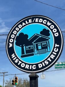
Wheeling is fortunate to have several National Historic Districts, with the newest being the Dimmeydale neighborhood. Other areas on the National Register of Historic Places are - Centre Market, Chapline Street Row, East Wheeling, Highland Park, Monroe Street East (part of 12th Street), North Wheeling, South Wheeling, National Road Corridor (between Bethan Pike and Park View Lane), Warwood, Downtown Wheeling, Wheeling Island, Wheeling Warehouse District and Woodsdale-Edgwood. Many individual buildings are also listed, along with a few additional properties outside of city limits but in Ohio County. Boundaries of many of these districts are marked with special signs.
In general, a listing does not restrict the sale or use of a property, with some requirements if federal or state funds are being used for rehabilitation. Listing does not require continued maintenance of a property, and it also does not guarantee funding for maintenance.
Listing does not prevent demolition, but the City of Wheeling requires prior review by the Historic Landmarks Commission for demolition of a contributing structure within any of its historic districts. A "contributing" structure is one that is considered to add to the historic association or architectural importance for which the district is significant and that retains most of its original architectural characteristics without significant alterations.
If a structure is listed as a contributing structure in a designated historic district, it is automatically considered to be on the National Register of Historic Places, and individual listing is not needed for grant eligibility or bragging rights.
Wheeling has also established three Design Review Districts where property owners have developed additional regulations to protect their historic investments. These are Chapline Street Row, Centre Market Square and North Wheeling. In those districts, rules govern visible exterior work and property owners are required to obtain a Certificate of Appropriateness for such work from the city's Historic Landmarks Commission. Specific rules for Design Review Districts vary from district to district and can be found on the city's website. None of these districts require special review for interior work.
The Dimmeydale Historic District Nomination was submitted for recognition in the fall of 2025 and includes 240 structures (222 contributing and 18 non-contributing) and one contributing site.
An introductory paragraph states: "The approximately 30.7-acre district is located in the Pleasant Valley area of Wheeling, directly north of Greenwood Cemetery and between National Road and Wheeling Creek. The gently rolling terrain slopes down to the west toward the creek. The compact neighborhood features residences constructed 1893 to 1973. Architectural styles include Colonial Revival, Dutch Colonial Revival, Craftsman, Tudor Revival, Minimal Traditional and Modern. The variety of residential styles illustrate the evolution of the neighborhood over time."
Also submitted as an historic district in 2025 was the Warwood Historic District -- a different type of neighborhood from the nearly entirely residential Dimmeydale but still historically and architecturally significant. An introduction to its 1244 structures includes, "Warwood's setting and layout is that of an early 20th century mixed-use neighborhood where people lived, worked, shopped, attended church and school, and socialized within a walkable area. The neighborhood consists of streets lined predominantly with single-family homes punctuated by large manufacturing facilities and city infrastructure such as a water treatment plant. On Warwood's western edge, the Pittsburgh, Cincinnati, Chicago and St. Louis Railroad (P.C.C.& St. L), a branch of the Pennsylvania Railroad, traveled in a north-south direction along the banks of the Ohio River. Built between the railroad line and Ohio River were factories including Warwood Tool Company, U.S. Corrugated Fiber Box Company and Continental Can Company."
A small historic district is Chapline Street Row -- the eight homes from 2301 through 2323 Chapline St. This district became official in 1984 and has been described as "the best extant example of a series of high style Victorian structures in West Virginia. These imaginative homes of the 19th century demonstrate American architectural ingenuity. The materials were selected for quality and endurance, and the craftsmen obviously took pride in their work. These homes are visible reminders of the owners who were for the most part wealthy and/or influential people in Wheeling." Fortunately, most of the buildings in this row are being lovingly maintained.
An even smaller district is Monroe Street East, with only six properties. This district is just one block long, along 12th Street, which was historically named Monroe Street. "The striking 1837 Greek Revival Church [which is known locally as 'The Blue Church'] is the focal point in the district as viewed from 12th Street. Below, on the south side, are two large buildings: one is an 1852 dignified Romano-Tuscan home [100 12th Street] while the other is a striking 1881 building with lively combinations of architectural details [96 12th Street]. The structures on the north side are dominated by the handsome Richardsonian Romanesque structure which is flanked by vernacular post-Civil War townhouses with significant front elevation alterations [93, 97, 99, 99 ½, and 101 12th Street]."
A map showing the historic districts can be found on the City of Wheeling's website (https://www.wheelingwv.gov) by clicking on the Maps icon and selecting the Historic Districts layer. This map was recently updated by Bel-O-Mar.
A full, descriptive list of districts and individual properties can be found at: https://wvculture.org/agencies/state-historic-preservation-office-shpo/register-of-historical-places/national-register-of-historic-places-nominations/ohio-county/
Organizations such as Wheeling Heritage, Ritchietown Renaissance (South Wheeling), Victorian Old Town Association (North Wheeling) and Friends of Wheeling are actively involved in the preservation of our historic resources, working to protect these structures for future generations to enjoy.
More information on Friends of Wheeling can be found at: https://wheelingheritage.org/friends-of-wheeling/.